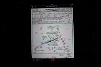
Another use of iPad, as a replacement for the Electronic Flight Bag, where all the navigation and the airport charts were kept, and can be access easily by a matter of tapping.

Firstly, Jeppesen application called JeppTC and JeppFD must be available ( with licence ofcourse ) . With the Licence Number, all the charts and Jepp manual can be downloaded, as good as having Jepp paper manual.

On the JeppFD, fill up the origin, destination, alternate and the routing as per the FMS.


The routing and the SID of the departure airport.

The enroute airport, once tapped on the screen.
Runway length, elevation, freqeuncies, all available.

 The Jepp manual if you want to read or refer can be recalled, and the approach chart for the destination.
Airport layout , parking position etc etc all available.


